 Home
Every history has got a story. Of course stories are the instruments that narrate history. Likewise the history behind the origin of seven summits has also got several stories to speak up. This article will summarize those stories and reveals you with the real reasons for naming these mountains so.
Before to enter with the matter one should have a clear idea about the members of the Seven summits. Well the Seven summits really denotes the seven highest peaks each one representing one of the seven continents in the world. We all knew that the seven continents that are existing right now can be listed out in the descending order on basis of their area as: ASIA, AFRICA, NORTH AMERICA, SOUT AMERICA, ANTARCTICA, EUROPE and AUSTRALIA
Belonging to any one of the continents listed above, Seven summits can be listed as:
- Aconcagua
- Carstensz Pyramid
- Kilimanjaro
- Elbrus
- Denali
- Vinson
- Mount Everest
Starting with Aconcagua which represents the continent South America, the story of it seems to be quite confusing as records say there are three reasons behind it's naming. On linguistic grounds it is believed that the name of this peak is derived from "Quechuan" language which is the combination of two words "Ackhon Cahuak" and "Anco Cahuac". The words are not of fancy and they really mean "Sentinel of stone" and "White Sentinel". Mean while the ancient people of Andes called the "Mapuches", named as "Aconca- Hue" which means "Comes from the other side".
Carstensz Pyramid which is probably now known as Puncak Jaya, this mountain is located on the island of New Guinea and stands as the highest peak in Indonesia. This mountain was named Carstensz Pyramid by a Dutch explorer Jan Carstensz in the year 1623 who, when he returned to Europe, was almost punished for claiming that there was a mountain near the equator with snow on it. The present name of the mountain is Puncak Jaya which came about in the 1960s when Indonesia took over control. The name was first changed to Puncak Soekarno after the president of Indonesia, but was later changed to Puncak Jaya, Jaya meaning 'victorious' or 'glorious'.
In the North East Tanzania lies the Mount Kilimanjaro which is the highest free-standing mountain in the world. The exact meaning of the word Kilimanjaro is unknown as it is thought to be a mixture of the Swahili and Kichagga languages.
Elbrus which represents the continent of Europe has the pride to be the highest peak of Europe. The mere translation of Elbrus in the Arabic language is "Surprise; surprise; White mountain".
The Denali range is the highest peak of North America which is exactly located in Alaska. The name is discovered by the natives of Alaska called the "Athabaskans" which means "The Great one".
The Vinson range is located in the freezing Antarctica. It is officially given this name by the US advisory committee on Arctic names due to great financial support of the congressman Carl Vinson.
The Everest needs no introductions as we all know it seems to be one of nature's wonders. Many interesting stories swirl around when we put ourselves in discovering the origin of it's name. of all the valuable fact is that this highest range acquires it's name from "Colonel George Everest" who was the chief of the surveyor who actually measured the real height of this peak to this world.
Article Source: http://EzineArticles.com/?expert=Lei_W_Wang
Lei Wang is the first Chinese woman and Asian-American woman to achieve the 'Seven Summits'. An unique mountaineering challenge consisting of climbing the highest mountain on each of the seven continents.
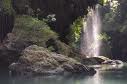
This tourist attraction located in the Village Kertayasa, Cijulang District, and located along the river Cijulang - about 31 km from Pangandaran. The nickname Cukang Taneuh arose because in the middle of the river there is a bridge of land as wide as 3 meters with 40 meters long. The bridge connects the two villages also became famous attractions, namely the Village Batukaras Kertayasa. Batukaras Beach known as surfing area.
Green Canyon became very popular, because the river is very beautiful. Those that visit there would have been transfixed by the beauty of the river which flows along the Cijulang. The beauty that will always greet tourists so go into the gate attractions.
The river is so special, because it lengthwise and sliced a canyon area of the physical structure is very admirable. Those who had visited the Green Canyon in Colorado, United States, will surely agree that the canyon in Cijulang was very similar to Green Canyon.
Any one have never visited, would be challenged to be there. Because, be invited to enjoy the beauty of the canyon with boating. While enjoying a boat trip can be climbed from Pier Ciseuruh, travelers will be treated to incredible natural scenery along the left and right sides of rivers. Various animals, like monkeys, always ready to welcome tourists with shouts.
To get to the first point, we must pass through a relatively calm river for nearly 15 minutes. After passing through the 'tunnel' of the river, we will then meet with a place that forces us to get off the boat. In these places, we will encounter a row of a rock which is very beautiful with stalactite and stalagmite decorations charming. Coral reefs also are forcing us to not continue the journey by boat, because the river channel was blocked by him until the river seems like a staircase rise.
Tourists at this point was challenged to dare to swim as far up the river . Those who did it and made it through the hurdles slow-moving river with a depth of about 10 meters, then we will be treated to views of waterfalls Palatar very charming.
There are many ways to reach the Green Canyon. The first objective that must be passed by tourists is preserved. So, try before you get to the area. It's up to you to use private or public vehicles, both good choices.
For those who use public transport, the time until Pangandaran, which must be done is to find a vehicle canal. The choice, either renting or riding public transportation buses. It cost just Rp 6000 just to get to the Green Canyon.
But, if you still want to use a leased vehicle, it is also not a bad choice. Lots of motorcycle or a car rental place in Pangandaran or Batukaras Beach. However, because the vehicles are usually rented for a full day, then the rental price becomes quite expensive.
The route should you take to achieve the Green Canyon is also very easy. From Jakarta or Bandung, you can follow the route to Central Java. Once you arrive at the fork in the road Banjar-Ciamis, should turn to the right direction and do not take straight. For those who use public transport, would not have to think about the route. Because the driver will take you to Pangandaran. That must be considered is the place to stay there. You can choose to stay at hotels that are available lots in Pangandaran. Or, it could also stay at the Beach Batukaras very close to the Green Canyon. The price also varies from hotel to the starry jasmine classes there.
artkel directory : various sources

A rucksack that is too small to carry all of your items is obviously no good, so make sure you know how much you intend to carry and what size bag you will need. Anything less that 20 litres is only suitable for the bare essentials. Even a small school bag will probably need to be 20-30 litres.
For a hostelling trip, a minimum of 50 litres is needed, depending on how long you are travelling and whether you'll be taking your own sleeping bag or other items. But for camping and hiking, you'll need at least 60 or 70 litres. For an intense expedition, you might even need to consider 90-100 litres or even bigger.
Be careful not to get a bag that is too big though. If the contents can move around easily, the bag is likely to get uncomfortable. And if there is lots of space, you may be tempted to fill it with heavy souvenirs.
You also need to take the material strength into consideration.
Small bags may not need to be very strong, but be aware that school bags are likely to be thrown around by unruly children so take the usage into consideration, not just the size. Obviously, larger bags will need to be stronger to carry the extra weight, and outdoor expeditions will also put extra strains on your bags so this will dictate even stronger materials.
The strength is given by the material thickness. 300D (denier) or less is fairly standard for small bags (but consider investing in a stronger one if the needs dictate this). For hostelling and travelling, you should be looking at 600D or more, especially for camping trips. Intensive outdoor expeditions should really be using bags with 900-1200D.
If the bag will be used outside a lot, it may be worth considering a waterproof rucksack, or a waterproof cover for it. Remember, though, that water will still be able to enter via the zips and openings, so these are not suitable for full submersion. Dedicated drybags will be needed if you are likely to be dropping your bags in any water.
Some rucksacks also have external webbing which allows your to attach other items to the outside of your rucksack. This can be useful for carry tents and other large items, enabling you to buy a cheaper, smaller rucksack and still be able to carry the same amount. It is also a useful back up if you run out of space inside.
A large bag with a single space can make it very difficult to find your smaller items. So a lot of larger rucksacks have side pockets and internal separators so that you can divide your possessions into suitable compartments. This makes it much easier to find your smaller items (such as your passport when you're being hassled by an impatient border guard).
For a hostelling trip, a minimum of 50 litres is needed, depending on how long you are travelling and whether you'll be taking your own sleeping bag or other items. But for camping and hiking, you'll need at least 60 or 70 litres. For an intense expedition, you might even need to consider 90-100 litres or even bigger.
Be careful not to get a bag that is too big though. If the contents can move around easily, the bag is likely to get uncomfortable. And if there is lots of space, you may be tempted to fill it with heavy souvenirs.
You also need to take the material strength into consideration.
Small bags may not need to be very strong, but be aware that school bags are likely to be thrown around by unruly children so take the usage into consideration, not just the size. Obviously, larger bags will need to be stronger to carry the extra weight, and outdoor expeditions will also put extra strains on your bags so this will dictate even stronger materials.
The strength is given by the material thickness. 300D (denier) or less is fairly standard for small bags (but consider investing in a stronger one if the needs dictate this). For hostelling and travelling, you should be looking at 600D or more, especially for camping trips. Intensive outdoor expeditions should really be using bags with 900-1200D.
If the bag will be used outside a lot, it may be worth considering a waterproof rucksack, or a waterproof cover for it. Remember, though, that water will still be able to enter via the zips and openings, so these are not suitable for full submersion. Dedicated drybags will be needed if you are likely to be dropping your bags in any water.
Some rucksacks also have external webbing which allows your to attach other items to the outside of your rucksack. This can be useful for carry tents and other large items, enabling you to buy a cheaper, smaller rucksack and still be able to carry the same amount. It is also a useful back up if you run out of space inside.
A large bag with a single space can make it very difficult to find your smaller items. So a lot of larger rucksacks have side pockets and internal separators so that you can divide your possessions into suitable compartments. This makes it much easier to find your smaller items (such as your passport when you're being hassled by an impatient border guard).
Article Directory: http://www.articledashboard.com
There are many good place to visit in Garut and here some Exploring Adventure Destination that perhaps you want to know.
Mount Papandayan
Regions object of Mount Papandayan have an area 7132 ha, consisting of a Nature Reserve with an area of 6807 hectares and 225 hectares of Natural Park. The type of this mountain is a type of volcano has a height of 2622 m above sea level. While the number of craters Papandayan have many active craters, some of which there are four craters that erupted in 2002, namely the New Crater, Nagklat crater and crater 2002 (2).
The appeal of the main form of the volcano crater, panoramic, mountain and camp, all this can be done in TWA potential attraction there is a forest in the Nature Reserve (CA) that are specifically for research and education (from ITB routinely carried out every year) and outside the region there are plantations of the garden belonging PTPN8 Sedep, Bandung.
The main activities that can be done that is tracking, hiking, photography and forest recreation that all this can be done in the TWA. While the activity is supporting the research of fauna and flora of the CA and for the picnic and camping can be done at the TWA.
Mount Cikuray
Cikuray Mountain is the highest mountain in Garut. Carrying 2821 meters high above sea level. Because that's the height, this mountain is very easily recognized and viewed from various directions. It is located in the southern city of Garut, exactly in between the region and the article is Cilawu. Besides known height, this mountain is also the symbol of natural riches Garut.
Until now natural panorama of Mount Cikuray great demand of tourists, both domestic and foreign tourists. Many of those who come to Cikuray tempted to climb the mountain, looking at the beautiful scenery around it. Although the mountain has no such crater of Mount Guntur or Papapandayan, but no less interesting for its natural panoramic view from the other mountains in the surrounding mountains.
Mount Guntur
Mount Guntur is one of the mountain is owned by Garut district, which is located in the village of Kampung Dukuh Pananjung Sub Tarogong Kaler. Mount Guntur is a mountain that is still active with this volcanic activity has a height of 2000 m above sea level and has a crater contained in one peak. Mount Guntur has a unique landscape character which has three hills on the peak, each hill has a height of 1000 m (from the foot of the mountain), 1200 m and 1300 m at the highest peak. This mountain has a form of appeal challenging mountain terrain, valleys, waterfalls, rivers, natural panorama and craters. Mount Guntur has the general configuration of the land is mountainous with very steep slope and has a soil material in the form of rocky sand. For the stability of the land area classified as unstable, with high levels of land slope and soil absorption is enough.
Mount Guntur Regions TWA has not been intensively developed for tourism zone, it's just a lot of Mount Guntur visited the explorers and used as an area for camping, hiking and tracking.
Talaga Bodas
Talaga Bodas Crater TWA region has an area of 23.85 hectares and located at an altitude of 1512 m above sea level. This tourist attraction is a natural tourist park with white water.
Soil stability and water absorption region is at middle. Type of soil material is rock, rocky soil. Talaga Bodas Crater environmental conditions quite well with the cleanliness and landscape that is fair, visitors who come to the TWA is usually done tracking tours, hiking, photography, picnic, or just a walk and refreshing .
So...interesting to exploring them..???
Article Source: garutkab.go.id
Mount Papandayan
Regions object of Mount Papandayan have an area 7132 ha, consisting of a Nature Reserve with an area of 6807 hectares and 225 hectares of Natural Park. The type of this mountain is a type of volcano has a height of 2622 m above sea level. While the number of craters Papandayan have many active craters, some of which there are four craters that erupted in 2002, namely the New Crater, Nagklat crater and crater 2002 (2).
The appeal of the main form of the volcano crater, panoramic, mountain and camp, all this can be done in TWA potential attraction there is a forest in the Nature Reserve (CA) that are specifically for research and education (from ITB routinely carried out every year) and outside the region there are plantations of the garden belonging PTPN8 Sedep, Bandung.
The main activities that can be done that is tracking, hiking, photography and forest recreation that all this can be done in the TWA. While the activity is supporting the research of fauna and flora of the CA and for the picnic and camping can be done at the TWA.
Mount Cikuray
Cikuray Mountain is the highest mountain in Garut. Carrying 2821 meters high above sea level. Because that's the height, this mountain is very easily recognized and viewed from various directions. It is located in the southern city of Garut, exactly in between the region and the article is Cilawu. Besides known height, this mountain is also the symbol of natural riches Garut.
Until now natural panorama of Mount Cikuray great demand of tourists, both domestic and foreign tourists. Many of those who come to Cikuray tempted to climb the mountain, looking at the beautiful scenery around it. Although the mountain has no such crater of Mount Guntur or Papapandayan, but no less interesting for its natural panoramic view from the other mountains in the surrounding mountains.
Mount Guntur
Mount Guntur is one of the mountain is owned by Garut district, which is located in the village of Kampung Dukuh Pananjung Sub Tarogong Kaler. Mount Guntur is a mountain that is still active with this volcanic activity has a height of 2000 m above sea level and has a crater contained in one peak. Mount Guntur has a unique landscape character which has three hills on the peak, each hill has a height of 1000 m (from the foot of the mountain), 1200 m and 1300 m at the highest peak. This mountain has a form of appeal challenging mountain terrain, valleys, waterfalls, rivers, natural panorama and craters. Mount Guntur has the general configuration of the land is mountainous with very steep slope and has a soil material in the form of rocky sand. For the stability of the land area classified as unstable, with high levels of land slope and soil absorption is enough.
Mount Guntur Regions TWA has not been intensively developed for tourism zone, it's just a lot of Mount Guntur visited the explorers and used as an area for camping, hiking and tracking.
Talaga Bodas
Talaga Bodas Crater TWA region has an area of 23.85 hectares and located at an altitude of 1512 m above sea level. This tourist attraction is a natural tourist park with white water.
Soil stability and water absorption region is at middle. Type of soil material is rock, rocky soil. Talaga Bodas Crater environmental conditions quite well with the cleanliness and landscape that is fair, visitors who come to the TWA is usually done tracking tours, hiking, photography, picnic, or just a walk and refreshing .
So...interesting to exploring them..???
Article Source: garutkab.go.id
Tourist attraction and appeal of sport Paragliding Haruman Mount is located in the village of Sari Haruman, Kadungora District, Garut regency, West Java Province. Ownership status of land used for community land Paragliding is still not managed specifically. Mount Haruman have more or less the level of 1300 m above the sea and the mountain is not a type of volcano. General configuration of land is mountainous with steep slope land is absorbent, soil satabilitas good and kind of material is generally sandy rocky soil. Mount Haruman is an object used for sport Paraglaiding for those lovers of kite flying.
The basis used to fly kites have 40 x 15 m2 area with grass surface layer with a slope of sloping land. To make flying sport kites, each visitor usually bring their own equipment, this is due to the lack of specific management that is not available the necessary equipment.
To reach the area of Mount Haruman glide we can through the highway Garut - Bandung, which passed the District of Kadungora. From Sub Kadungora can use private vehicles or ojeg towards the village of Sari Haruman. The distance traveled from village to district Kadungora Haruman Sari is approximately 15 km with 2-4 m wide road that has less road quality. Whereas for the airstrip to fly from the village of Sari Haruman is 7-8 km, which is usually the visitors use the jeep or the like, this is caused by a badly damaged condition of the road so it does not allow to pass by other cars and Jeeps.
Exploring activities conducted in this region is to fly kites, tracking, enjoying the scenery and photography. Think to try this..???
The basis used to fly kites have 40 x 15 m2 area with grass surface layer with a slope of sloping land. To make flying sport kites, each visitor usually bring their own equipment, this is due to the lack of specific management that is not available the necessary equipment.
To reach the area of Mount Haruman glide we can through the highway Garut - Bandung, which passed the District of Kadungora. From Sub Kadungora can use private vehicles or ojeg towards the village of Sari Haruman. The distance traveled from village to district Kadungora Haruman Sari is approximately 15 km with 2-4 m wide road that has less road quality. Whereas for the airstrip to fly from the village of Sari Haruman is 7-8 km, which is usually the visitors use the jeep or the like, this is caused by a badly damaged condition of the road so it does not allow to pass by other cars and Jeeps.
Exploring activities conducted in this region is to fly kites, tracking, enjoying the scenery and photography. Think to try this..???
One of the explore activity in the Garut was rafting at the Cikandang. located in the Village Sukamulya Pakenjeng. This tourism object is situated 400 m above sea level with the general configuration of the land is mountainous and hilly. The length of the river which is often used as a tourist attraction is 28 km with a width of 5-8 m. Environmental quality and cleanliness of the river Cikandang well as the region is classified as white water rafting is still very natural. Level of the river rather steep slope with soil stability and good absorption. The average temperature ranges between 30-40’ C with an average sun shines hot and there is the influence of belonging to the season during the rainy season the water in the river Cikandang very heavy so it is better to conduct white water rafting, while during the dry season to subside so the white water rafting activities difficult. Categorized wind strength is not too large.
Cikandang river waters in brownish-green water with the smell and temperature normal. Average high flows in the River Cikandang 1-2 m, so it is a challenge that challenging white water rafting activities. Riverbed material such as mud, stone and gravel to the riverbed slope levels varied, from flat to steep. and the type of ground cover in the form of clay and rocks. The dominant flora of the river is the coconut tree. albasiah wood, bamboo and other woods, while along the riverbank there is fauna like monkeys and several species of birds. Abrasion levels pertained small but ever landslide occurred in the village which was passed by the river Neglasan Cikandang. Visabilitas level in this region are still free due to a natural, and low noise level.
There are obstacles in the form of difficulty or lack of communication tools in this area, not because the phone lines and the limited availability of communication tools that are available is a handy talkie. Activities that can be done in this area, among other "white water rafting and river scenery.
This object is 36 km from the center of district administration, and transportation equipment that can be used to achieve this object other than a personal vehicle is a micro bus with majors Garut Pameungpeuk rate of Rp 6000. Pakenjeng has over 25 km of provincial roads, district roads along the 17 km and 126 km of village roads.
Cikandang river waters in brownish-green water with the smell and temperature normal. Average high flows in the River Cikandang 1-2 m, so it is a challenge that challenging white water rafting activities. Riverbed material such as mud, stone and gravel to the riverbed slope levels varied, from flat to steep. and the type of ground cover in the form of clay and rocks. The dominant flora of the river is the coconut tree. albasiah wood, bamboo and other woods, while along the riverbank there is fauna like monkeys and several species of birds. Abrasion levels pertained small but ever landslide occurred in the village which was passed by the river Neglasan Cikandang. Visabilitas level in this region are still free due to a natural, and low noise level.
There are obstacles in the form of difficulty or lack of communication tools in this area, not because the phone lines and the limited availability of communication tools that are available is a handy talkie. Activities that can be done in this area, among other "white water rafting and river scenery.
This object is 36 km from the center of district administration, and transportation equipment that can be used to achieve this object other than a personal vehicle is a micro bus with majors Garut Pameungpeuk rate of Rp 6000. Pakenjeng has over 25 km of provincial roads, district roads along the 17 km and 126 km of village roads.
Before, if you want to buy camping gear, you need to go personally to a camping retail store to get what you need. But ever since the birth of Internet, purchasing products like camping supplies and equipment has become a lot easier. Now, all you need to do is to sit in front of the computer and surf the net to find what you are looking for. Once you find it, you can order it, pay using your credit card, and voila, it arrives in your doorstep a few days later.
It is not any different if you are planning to buy a camping bed. You can readily buy it from one of the various online camping stores. However, it is important to equip yourself with knowledge on the ins and outs of online shopping so that you will be able to find the best portable cot from this market. To do that, here are some practical tips to consider.
1. Go for topnotch brands.
There are many reputable brands to choose from. Some of the brands to consider include Browning, Big Sky, Bunkmaster, Converta Cot, Overnighter, and Coleman beds. Going for a respectable name is not just about choosing what is popular. More importantly, a brand reflects the product's quality. This means that choosing these brands would ensure you quality and durability.
2. Search for a trustworthy store.
Even if you buy a first-rate brand but if you purchase it from a fraudulent store, it is no use. You will either end up being axed with a price that is too high or you get a fake version of the brand. This is why, it is imperative that you find a store that has a good reputation and has been in the industry long enough to know its way around.
Moreover, you have to check the store's customer service and website security. Get in touch with the store's former customers to find out if there have been any complaints made against them. Check the page of the website that asks for your credit card and personal information. The page should have the word, "https" before its web address and a closed padlock symbol that denote that the website is secure.
3. Understand online shopping procedures.
This is no joke, you really have to read everything. The terms and conditions, as well as policies on shipping, penalties, charges, costs, returns, cancellations, and so many more-you need to familiarize yourself with the online shopping procedures from the particular store you are buying from so you do not miss out anything important regarding your purchase. Be sure to read the fine print and inquire about hidden charges so you are not fooled.
4. Inspect your cot carefully upon delivery.
Right at the moment the product arrives on your doorstep, open it up and examine it to find out immediately if there are any flaws or defects. If there is, call up the store right away.
Finding the best portable cot online is not that difficult if you follow the simple tips mentioned above. You might be exerting extra effort on this purchase but you should not mind. After all, this will contribute to the success of your camping trips.
Article Source: http://EzineArticles.com/?expert=D_Coleman
It is not any different if you are planning to buy a camping bed. You can readily buy it from one of the various online camping stores. However, it is important to equip yourself with knowledge on the ins and outs of online shopping so that you will be able to find the best portable cot from this market. To do that, here are some practical tips to consider.
1. Go for topnotch brands.
There are many reputable brands to choose from. Some of the brands to consider include Browning, Big Sky, Bunkmaster, Converta Cot, Overnighter, and Coleman beds. Going for a respectable name is not just about choosing what is popular. More importantly, a brand reflects the product's quality. This means that choosing these brands would ensure you quality and durability.
2. Search for a trustworthy store.
Even if you buy a first-rate brand but if you purchase it from a fraudulent store, it is no use. You will either end up being axed with a price that is too high or you get a fake version of the brand. This is why, it is imperative that you find a store that has a good reputation and has been in the industry long enough to know its way around.
Moreover, you have to check the store's customer service and website security. Get in touch with the store's former customers to find out if there have been any complaints made against them. Check the page of the website that asks for your credit card and personal information. The page should have the word, "https" before its web address and a closed padlock symbol that denote that the website is secure.
3. Understand online shopping procedures.
This is no joke, you really have to read everything. The terms and conditions, as well as policies on shipping, penalties, charges, costs, returns, cancellations, and so many more-you need to familiarize yourself with the online shopping procedures from the particular store you are buying from so you do not miss out anything important regarding your purchase. Be sure to read the fine print and inquire about hidden charges so you are not fooled.
4. Inspect your cot carefully upon delivery.
Right at the moment the product arrives on your doorstep, open it up and examine it to find out immediately if there are any flaws or defects. If there is, call up the store right away.
Finding the best portable cot online is not that difficult if you follow the simple tips mentioned above. You might be exerting extra effort on this purchase but you should not mind. After all, this will contribute to the success of your camping trips.
Article Source: http://EzineArticles.com/?expert=D_Coleman
Subscribe to:
Posts (Atom)
